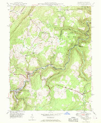
1949 Map of Gorman
USGS Topo · Published 1970About this map
The North Branch Potomac River defines the border between Maryland and West Virginia in this mid-century survey, anchoring a landscape of steep valleys and industrial activity. The settlement of Gorman and its cross-river neighbor Gormania serve as a focal point for local commerce and transportation, where the Western Maryland railroad follows the river's bend. To the west, the George Washington Highway traverses the terrain near the site of Fort Pendleton, a location of strategic significance.
Find a feature on this map
60 named features on this map. Tap any name to fly to it.
Don’t see what you’re looking for? This feature index may not catch every label — zoom into the map to look around manually.
Map Details
Editions of this 1949 Gorman Map
4 editions found
Other maps of this area

1895 · Piedmont
USGS Topo · 1:125,000

1899 · Oakland
USGS Topo · 1:62,500

1900 · Oakland
USGS Topo · 1:62,500

1916 · Davis
USGS Topo · 1:48,000

1918 · Davis
USGS Topo · 1:62,500

1919 · Elk Garden
USGS Topo · 1:48,000

1919 · Davis
USGS Topo · 1:62,500

1920 · Elk Garden
USGS Topo · 1:48,000

1920 · Davis
USGS Topo · 1:48,000

1921 · Greenland Gap
USGS Topo · 1:62,500