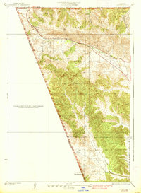
1938 Map of Gorman
USGS Topo · Published 1938About this map
The Tehachapi Mountains and the dramatic geological depression of the San Andreas Rift Zone Valley dominate this terrain on the boundary of Kern, Los Angeles, and Ventura counties. In the 1930s, this area served as a critical mountain gateway for California travelers, centered on the settlement of Gorman and the famous Tejon Pass. The transportation network is remarkably detailed, featuring the legendary Ridge Route and the Frazier Mtn Park Road, tracing the path of early automotive travel through the Castac Valley. A long-distance Transmission Line cuts across the mountains, while scattered water sources like the Canada de los Alamos and various unnamed springs highlight the arid challenges of the high-country landscape. Further south, the map reveals more remote ranching and forest lands within the Los Padres National Forest, including the Alamo Ranch and the small outpost of Chandler.
Find a feature on this map
20 named features on this map. Tap any name to fly to it.
Don’t see what you’re looking for? This feature index may not catch every label — zoom into the map to look around manually.
Map Details
Editions of this 1938 Gorman Map
3 editions found
Other maps of this area

1903 · Tejon
USGS Topo · 1:125,000

1932 · Beartrap Canyon
USGS Topo · 1:24,000

1933 · Quail
USGS Topo · 1:24,000

1933 · Gorman
USGS Topo · 1:24,000

1938 · Beartrap Canyon
USGS Topo · 1:24,000

1938 · Gorman
USGS Topo · 1:24,000

1938 · Black Mountain
USGS Topo · 1:24,000

1938 · Quail
USGS Topo · 1:24,000

1942 · Frazier Mountain
USGS Topo · 1:24,000
1944 · Frazier Mountain
USGS Topo · 1:31,680