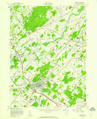
1957 Map of Goshen
USGS Topo · Published 1959About this map
Goshen serves as the focal point of this mid-century survey, revealing a landscape defined by harness racing traditions and substantial institutions. The village core is notable for its proximity to the Historic Track and Good Time Park, reflecting the area's deep equestrian heritage. Surrounding the town, the Erie RR winds through a mix of agricultural land and scattered educational and religious sites, such as the Selesian Sch and the Blessed Sacrament Academy.
Find a feature on this map
72 named features on this map. Tap any name to fly to it.
Don’t see what you’re looking for? This feature index may not catch every label — zoom into the map to look around manually.
Map Details
Editions of this 1957 Goshen Map
3 editions found
Other maps of this area

1902 · Schunemunk
USGS Topo · 1:62,500

1903 · Newburg
USGS Topo · 1:62,500

1904 · Ellenville
USGS Topo · 1:62,500

1906 · Ellenville
USGS Topo · 1:62,500

1906 · Goshen
USGS Topo · 1:62,500

1908 · Goshen
USGS Topo · 1:62,500

1930 · Schunemunk
USGS Topo · 1:48,000

1935 · Schunemunk
USGS Topo · 1:62,500

1938 · Goshen
USGS Topo · 1:62,500

1942 · Pine Island
USGS Topo · 1:24,000