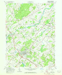
1957 Map of Goshen
USGS Topo · Published 1972About this map
The village of Goshen serves as the focal point of this mid-century Orange County landscape, characterized by its historical transit infrastructure and traditional town planning. The Erie RR defines the movement across the terrain, connecting outlying hamlets like Campbell Hall and Phillipsburg. A notable concentration of social and civic history is visible in the town's center, including the famed Historic Track and Good Time Park, reflecting the area's equestrian heritage.
Find a feature on this map
80 named features on this map. Tap any name to fly to it.
Don’t see what you’re looking for? This feature index may not catch every label — zoom into the map to look around manually.
Map Details
Editions of this 1957 Goshen Map
3 editions found
Other maps of this area

1902 · Schunemunk
USGS Topo · 1:62,500

1903 · Newburg
USGS Topo · 1:62,500

1904 · Ellenville
USGS Topo · 1:62,500

1906 · Ellenville
USGS Topo · 1:62,500

1906 · Goshen
USGS Topo · 1:62,500

1908 · Goshen
USGS Topo · 1:62,500

1930 · Schunemunk
USGS Topo · 1:48,000

1935 · Schunemunk
USGS Topo · 1:62,500

1938 · Goshen
USGS Topo · 1:62,500

1942 · Pine Island
USGS Topo · 1:24,000