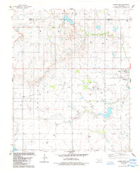
1984 Map of Gotebo West
USGS Topo · Published 1985About this map
Rainy Mountain Indian Treaty Boundary slices across the northern reaches of this landscape, marking a significant historical line in Kiowa and Washita counties. The terrain is defined by a dense industrial network of an active Oil Field, with numerous Oil Wells, Gas Wells, and Injection Wells scattered across the plains and around Tanny Hill. This mid-1980s landscape shows the transition from earlier rail-based commerce to a petroleum-driven economy, evidenced by the Old Railroad Grade that once connected the local hubs.
Find a feature on this map
17 named features on this map. Tap any name to fly to it.
Don’t see what you’re looking for? This feature index may not catch every label — zoom into the map to look around manually.
Map Details
Editions of this 1984 Gotebo West Map
This is the sole edition of this map. No revisions or reprints were ever made.
Other maps of this area

1949 · Cooperton
USGS Topo · 1:62,500

1955 · Lawton
USGS Topo · 1:250,000

1955 · Clinton
USGS Topo · 1:250,000

1956 · Unap Mountain
USGS Topo · 1:24,000

1956 · Rainy Mountain Creek
USGS Topo · 1:24,000

1956 · Cooperton
USGS Topo · 1:62,500

1957 · Clinton
USGS Topo · 1:250,000

1961 · Gotebo
USGS Topo · 1:62,500

1961 · Hobart
USGS Topo · 1:62,500

1963 · Babbs
USGS Topo · 1:24,000