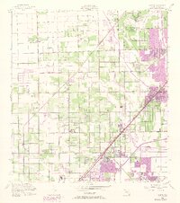
1956 Map of Goulds
USGS Topo · Published 1974About this map
Goulds and its neighboring communities are captured during a period of transition as the South Florida agricultural landscape begins to meet expanding urban development. The Seaboard Coast Line railroad forms a diagonal spine through the region, connecting the rural settlements of Princeton, Naranja, and Modello. This map highlights significant institutional footprints, including the University of Miami (South Campus) and the sprawling U S Naval Air Station (Inactive), which occupies a massive tract in the northeast.
Find a feature on this map
36 named features on this map. Tap any name to fly to it.
Don’t see what you’re looking for? This feature index may not catch every label — zoom into the map to look around manually.
Map Details
Editions of this 1956 Goulds Map
4 editions found
Other maps of this area

1949 · South Miami NW
USGS Topo · 1:24,000

1949 · Arsenicker Keys
USGS Topo · 1:24,000

1949 · Goulds
USGS Topo · 1:24,000

1949 · Perrine
USGS Topo · 1:24,000

1950 · Homestead
USGS Topo · 1:24,000

1950 · South Miami
USGS Topo · 1:24,000

1955 · South Miami NW
USGS Topo · 1:24,000

1956 · Goulds
USGS Topo · 1:24,000

1956 · Perrine
USGS Topo · 1:24,000

1956 · South Miami
USGS Topo · 1:24,000
Featured Places
- Princeton, FL
- Goulds, FL
- Naranja, FL
- Leisure Mobile Home Park-Modello Park, FL
- Pine Isle Mobile Home Park, FL