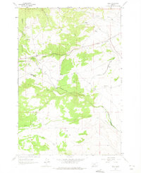
1963 Map of Grace
USGS Topo · Published 1975About this map
The Chicago Milwaukee St Paul And Pacific railroad defines the transportation corridor of this high-elevation landscape, following the winding path of Little Pipestone Creek through the mountains. Small settlements and rail stops like Grace, Nineteen Mile, and Cedric are situated along the tracks, serving as focal points in an otherwise sparsely populated terrain. Much of the western portion of the map is dominated by the Deerlodge National Forest, where the Toll Mountain Campground provides a developed recreation site near the North Fork.
Find a feature on this map
28 named features on this map. Tap any name to fly to it.
Don’t see what you’re looking for? This feature index may not catch every label — zoom into the map to look around manually.
Map Details
Editions of this 1963 Grace Map
3 editions found
Other maps of this area

1893 · Dillon
USGS Topo · 1:250,000

1955 · Dillon
USGS Topo · 1:250,000

1957 · Dillon
USGS Topo · 1:250,000

1958 · Dillon
USGS Topo · 1:250,000

1960 · Twin Bridges
USGS Topo · 1:62,500

1960 · Waterloo
USGS Topo · 1:62,500

1962 · Dillon
USGS Topo · 1:250,000
1963 · Dry Mountain
USGS Topo · 1:24,000

1963 · Pipestone Pass
USGS Topo · 1:24,000

1963 · Vendome
USGS Topo · 1:24,000