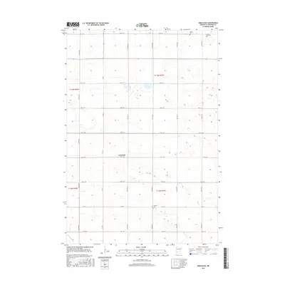
2016 Map of Gracelock
USGS Topo · Published 2016About this map
Gracelock sits at the center of this agricultural landscape in Chippewa County, where a rigid grid of section-line roads defines the rural character of the Minnesota prairie. The map reveals a pattern of scattered homesteads and local burial grounds, such as Hillside Cem and Buffalo Lake Cem in the northeast corner. This 2016 survey documents the enduring layout of the Public Land Survey System, with townships like t119n r39w and t118n r39w organized into precise one-mile squares. The terrain is marked by seasonal drainage and small basins, with the only named waterway being Dry Weather Cr winding through the southwest. Genealogists will find value in the specific placement of rural landmarks like Havelock Cem, located along Co Rd 13, which serve as permanent anchors in an otherwise changing farming region.
Find a feature on this map
37 named features on this map. Tap any name to fly to it.
Don’t see what you’re looking for? This feature index may not catch every label — zoom into the map to look around manually.
Map Details
Editions of this 2016 Gracelock Map
This is the sole edition of this map. No revisions or reprints were ever made.
Other maps of this area
1953 · New Ulm
USGS Topo · 1:250,000

1953 · Saint Cloud
USGS Topo · 1:250,000
1957 · Saint Cloud
USGS Topo · 1:250,000
1957 · New Ulm
USGS Topo · 1:250,000
1958 · New Ulm
USGS Topo · 1:250,000
1958 · Saint Cloud
USGS Topo · 1:250,000
1958 · Murdock
USGS Topo · 1:24,000
1958 · Gracelock NE
USGS Topo · 1:24,000
1958 · Kerkhoven SW
USGS Topo · 1:24,000
1958 · Gracelock NW
USGS Topo · 1:24,000