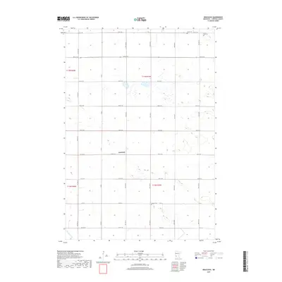
2019 Map of Gracelock
USGS Topo · Published 2019About this map
The unincorporated settlement of Gracelock sits at the heart of this agricultural landscape in Chippewa County, where a strict section-line road grid organizes the prairie. This 2019 survey documents a rural interior defined by its township boundaries, including t119n r39w and t118n r39w, where family farms are connected by an extensive network of numbered roads like Co Rd 6. The cultural history of the area is preserved in several small burial grounds, including Hillside Cem and Buffalo Lake Cem in the north and Havelock Cem to the south. Drainage for these fertile lands is provided by Dry Weather Cr, which winds through the southwestern corner. The map reveals a highly structured environment where the Jeffersonian grid remains the dominant force over a landscape dotted with numerous small wetlands and seasonal basins.
Find a feature on this map
39 named features on this map. Tap any name to fly to it.
Don’t see what you’re looking for? This feature index may not catch every label — zoom into the map to look around manually.
Map Details
Editions of this 2019 Gracelock Map
This is the sole edition of this map. No revisions or reprints were ever made.
Other maps of this area
1953 · New Ulm
USGS Topo · 1:250,000

1953 · Saint Cloud
USGS Topo · 1:250,000
1957 · Saint Cloud
USGS Topo · 1:250,000
1957 · New Ulm
USGS Topo · 1:250,000
1958 · New Ulm
USGS Topo · 1:250,000
1958 · Saint Cloud
USGS Topo · 1:250,000
1958 · Murdock
USGS Topo · 1:24,000
1958 · Gracelock NE
USGS Topo · 1:24,000
1958 · Kerkhoven SW
USGS Topo · 1:24,000
1958 · Gracelock NW
USGS Topo · 1:24,000