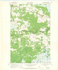
1968 Map of Graceton
USGS Topo · Published 1971About this map
Graceton sits along the northern edge of this northern Minnesota landscape, where the Canadian National railroad cuts a straight path through the timber and marshlands. This late-1960s survey captures a transition from the structured rail corridor to the dense wilderness of the Beltrami Island State Forest and the Red Lake Indian Reservation. The terrain is defined by a winding network of waterways, including the Winter Road River and the meandering Peppermint Creek, which dictate the few established routes through the area.
Find a feature on this map
13 named features on this map. Tap any name to fly to it.
Don’t see what you’re looking for? This feature index may not catch every label — zoom into the map to look around manually.
Map Details
Editions of this 1968 Graceton Map
This is the sole edition of this map. No revisions or reprints were ever made.
Other maps of this area

1918 · Williams
USGS Topo · 1:62,500

1919 · Peppermint Creek
USGS Topo · 1:62,500

1919 · Canada
USGS Topo · 1:62,500

1921 · Baudette
USGS Topo · 1:62,500

1943 · Peppermint Creek
USGS Topo · 1:62,500

1954 · Roseau
USGS Topo · 1:250,000

1957 · Roseau
USGS Topo · 1:250,000

1958 · Roseau
USGS Topo · 1:250,000

1967 · Williams
USGS Topo · 1:24,000
1967 · Williams SE
USGS Topo · 1:24,000