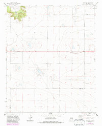
1971 Map of Grady SW
USGS Topo · Published 1987About this map
The Caprock dominates the northwest corner of this High Plains landscape, where the dramatic elevation change reveals the headwaters of Puerto Creek. This 1971 survey captures a sparsely populated ranching and agricultural region along the border of Quay and Curry counties. The small settlement of Watts serves as a primary local landmark, while the surrounding land is marked by the infrastructure of the era, including a major pipeline and isolated Landing Strips. Evidence of local industry and water management is scattered throughout the grid, from several Gravel Pit sites to a Water Tank and various wells that sustain life in this arid environment. A lone Cem stands as a quiet record of early residents who settled this transition zone between the plateau and the canyon floor.
Find a feature on this map
10 named features on this map. Tap any name to fly to it.
Don’t see what you’re looking for? This feature index may not catch every label — zoom into the map to look around manually.
Map Details
Editions of this 1971 Grady SW Map
2 editions found
Other maps of this area

1954 · Clovis
USGS Topo · 1:250,000

1957 · Hammond Ranch
USGS Topo · 1:62,500

1958 · Clovis
USGS Topo · 1:250,000
1971 · Apache Canyon
USGS Topo · 1:24,000

1971 · Wheatland
USGS Topo · 1:24,000
1971 · Norton
USGS Topo · 1:24,000

1971 · Grady
USGS Topo · 1:24,000

1971 · Grady SW
USGS Topo · 1:24,000

1971 · Forrest
USGS Topo · 1:24,000
1973 · Field
USGS Topo · 1:24,000