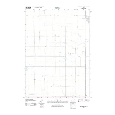
2010 Map of Graettinger West
USGS Topo · Published 2010About this map
The agrarian grid of Palo Alto County defines the landscape surrounding Graettinger, a community organized around the Graettinger Post Office in the northeast corner of the quadrangle. This 2010 survey illustrates a region where local heritage is preserved in several rural burial grounds, including Lost Island Lutheran Cemetery and Saint Pauls Cemetery, which serve as landmarks for early family settlements. The terrain is characterized by a high density of wetlands and marshlands, notably Fallow Marsh, Perkins Marsh, and Blue Wing Marsh, which interrupt the expansive township and range road system. Small localities like Fallow and Crippin Corners reflect the persistence of named rural junctions within this deeply rooted farming district. The map provides a clear record of the intersection between human settlement—marked by locations like Highland Cemetery—and the natural hydrology of the Iowa prairie.
Find a feature on this map
27 named features on this map. Tap any name to fly to it.
Don’t see what you’re looking for? This feature index may not catch every label — zoom into the map to look around manually.
Map Details
Editions of this 2010 Graettinger West Map
This is the sole edition of this map. No revisions or reprints were ever made.
Other maps of this area

1954 · Fairmont
USGS Topo · 1:250,000

1958 · Fairmont
USGS Topo · 1:250,000

1972 · Graettinger West
USGS Topo · 1:24,000

1972 · Terril
USGS Topo · 1:24,000

1972 · Wallingford
USGS Topo · 1:24,000

1972 · Ayrshire
USGS Topo · 1:24,000
1972 · Silver Lake
USGS Topo · 1:24,000
1972 · Ruthven
USGS Topo · 1:24,000

1980 · Ingham Lake
USGS Topo · 1:24,000

1980 · Graettinger East
USGS Topo · 1:24,000