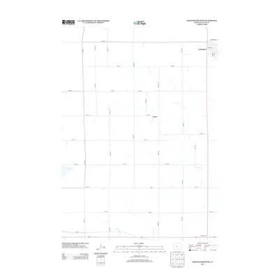
2013 Map of Graettinger West
USGS Topo · Published 2013About this map
Graettinger sits at the northeastern edge of this landscape, where the street grid of the town meets a highly organized agricultural interior. The map reveals a region defined by precise section lines and an extensive drainage network, including Ditch Number 132 and Ditch Number 176, which have fundamentally reshaped the hydrology of the prairie. Smaller named localities like Fallow and Crippin Corners appear as rural intersections, reflecting the enduring pattern of settlement that persists in the early 21st century. In the southwest, the presence of Blue Wing Marsh offers a contrast to the geometric precision of the surrounding farms, marking a remnant of the natural wetlands that once dominated Palo Alto County before the development of the modern drainage systems.
Find a feature on this map
27 named features on this map. Tap any name to fly to it.
Don’t see what you’re looking for? This feature index may not catch every label — zoom into the map to look around manually.
Map Details
Editions of this 2013 Graettinger West Map
This is the sole edition of this map. No revisions or reprints were ever made.
Other maps of this area

1954 · Fairmont
USGS Topo · 1:250,000

1958 · Fairmont
USGS Topo · 1:250,000

1972 · Graettinger West
USGS Topo · 1:24,000

1972 · Terril
USGS Topo · 1:24,000

1972 · Wallingford
USGS Topo · 1:24,000

1972 · Ayrshire
USGS Topo · 1:24,000
1972 · Silver Lake
USGS Topo · 1:24,000
1972 · Ruthven
USGS Topo · 1:24,000

1980 · Ingham Lake
USGS Topo · 1:24,000

1980 · Graettinger East
USGS Topo · 1:24,000