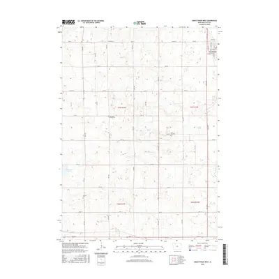
2015 Map of Graettinger West
USGS Topo · Published 2015About this map
Graettinger occupies the northeastern corner of this Palo Alto County landscape, where the grid of Jackson Ave and Cedar Ave marks the town's westward extent. The surrounding terrain is defined by a dense network of prairie wetlands and drainage infrastructure, reflecting a long history of managing the high water table for agriculture. Significant marshlands including Fallow Marsh, Perkins Marsh, and Blue Wing Marsh dot the countryside, while engineered waterways like Ditch Number 176 and Ditch Number 13 cut across the township lines. For genealogists, the map preserves the locations of several rural burial sites, including Lost Island Lutheran Cem, Saint Pauls Cem, and Highland Cem, which serve as quiet landmarks among the expansive farm plots and section roads of this Iowa prairie region.
Find a feature on this map
41 named features on this map. Tap any name to fly to it.
Don’t see what you’re looking for? This feature index may not catch every label — zoom into the map to look around manually.
Map Details
Editions of this 2015 Graettinger West Map
This is the sole edition of this map. No revisions or reprints were ever made.
Other maps of this area

1954 · Fairmont
USGS Topo · 1:250,000

1958 · Fairmont
USGS Topo · 1:250,000

1972 · Graettinger West
USGS Topo · 1:24,000

1972 · Terril
USGS Topo · 1:24,000

1972 · Wallingford
USGS Topo · 1:24,000

1972 · Ayrshire
USGS Topo · 1:24,000
1972 · Silver Lake
USGS Topo · 1:24,000
1972 · Ruthven
USGS Topo · 1:24,000

1980 · Ingham Lake
USGS Topo · 1:24,000

1980 · Graettinger East
USGS Topo · 1:24,000