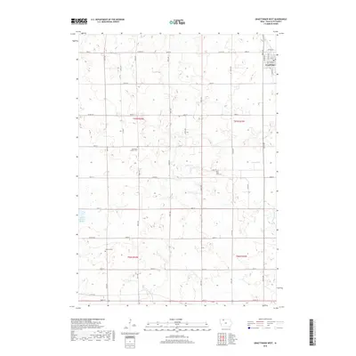
2018 Map of Graettinger West
USGS Topo · Published 2018About this map
Graettinger sits at the edge of a landscape defined by its complex hydrology and the grid-work of Palo Alto County's agricultural sections. The terrain is characterized by numerous glacial depressions that have formed significant wetlands, including Blue Wing Marsh, Fallow Marsh, and Perkins Marsh. These natural basins contrast with the deliberate engineering of the local drainage system, represented by several numbered waterways such as Ditch Number 135 and Ditch Number 876, which manage the water levels to support farming. For local historians and genealogists, the map identifies several rural burial grounds that anchor the area's pioneer heritage, including Lost Island Lutheran Cem, Saint Pauls Cem, and Highland Cem, each serving as a landmark for the families who settled this region of Iowa.
Find a feature on this map
29 named features on this map. Tap any name to fly to it.
Don’t see what you’re looking for? This feature index may not catch every label — zoom into the map to look around manually.
Map Details
Editions of this 2018 Graettinger West Map
This is the sole edition of this map. No revisions or reprints were ever made.
Other maps of this area

1954 · Fairmont
USGS Topo · 1:250,000

1958 · Fairmont
USGS Topo · 1:250,000

1972 · Graettinger West
USGS Topo · 1:24,000

1972 · Terril
USGS Topo · 1:24,000

1972 · Wallingford
USGS Topo · 1:24,000

1972 · Ayrshire
USGS Topo · 1:24,000
1972 · Silver Lake
USGS Topo · 1:24,000
1972 · Ruthven
USGS Topo · 1:24,000

1980 · Ingham Lake
USGS Topo · 1:24,000

1980 · Graettinger East
USGS Topo · 1:24,000