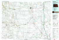
1985 Map of Grafton
USGS Topo · Published 1993About this map
The Grafton region of North Dakota and Minnesota is defined by the meanders of the Red River of the North and a vast network of irrigation and drainage infrastructure. This mid-1980s landscape shows the intricate water management required for agriculture in the Red River Valley, visible through numerous labeled channels like Judicial Ditch No 29 and County Ditch No 38. Several smaller rail-aligned settlements such as Minto, Lankin, and Fordville are connected by the Burlington Northern and Soo Line railroads, illustrating the area's historical reliance on rail for grain transport. Significant conservation areas, including the Ardoch National Wildlife Refuge and the Prairie Chicken State Wildlife Mgmt Area, provide a stark contrast to the surrounding grid-patterned townships like Fertile and Oakwood.
Find a feature on this map
119 named features on this map. Tap any name to fly to it.
Don’t see what you’re looking for? This feature index may not catch every label — zoom into the map to look around manually.
Map Details
Editions of this 1985 Grafton Map
2 editions found
Other maps of this area

1918 · Acton
USGS Topo · 1:62,500

1918 · Argyle
USGS Topo · 1:62,500

1918 · Warren
USGS Topo · 1:62,500

1926 · Ardoch
USGS Topo · 1:62,500

1934 · Emerado
USGS Topo · 1:48,000

1934 · Grand Forks
USGS Topo · 1:24,000

1934 · Grand Forks
USGS Topo · 1:62,500

1936 · Emerado
USGS Topo · 1:62,500

1936 · Larimore
USGS Topo · 1:62,500

1938 · Grand Forks
USGS Topo · 1:62,500