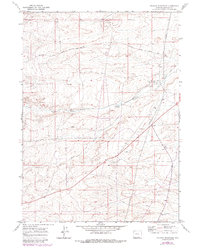
1969 Map of Graham Reservoir
USGS Topo · Published 1980About this map
The Emigrant Trail and Slate Creek Trail traverse this high-desert landscape in Lincoln County, highlighting the region's enduring importance as a corridor for westward movement. This 1969 field-checked survey reveals a sparsely populated terrain where water management is central to ranching life, evidenced by the Graham Ditch and the Graham Reservoir. Small-scale agricultural hubs like Slate Creek Ranch and the settlement of Graham anchor the local geography, supported by essential infrastructure such as a Landing Strip and multiple pipelines.
Find a feature on this map
20 named features on this map. Tap any name to fly to it.
Don’t see what you’re looking for? This feature index may not catch every label — zoom into the map to look around manually.
Map Details
Editions of this 1969 Graham Reservoir Map
2 editions found
Other maps of this area

1945 · Fort Hill
USGS Topo · 1:62,500

1947 · Fort Hill
USGS Topo · 1:62,500

1954 · Ogden
USGS Topo · 1:250,000

1955 · Preston
USGS Topo · 1:250,000

1958 · Ogden
USGS Topo · 1:250,000

1958 · Preston
USGS Topo · 1:250,000

1960 · Ogden
USGS Topo · 1:250,000

1962 · Preston
USGS Topo · 1:250,000

1968 · Fontenelle Reservoir SW
USGS Topo · 1:24,000

1969 · Willow Springs
USGS Topo · 1:24,000