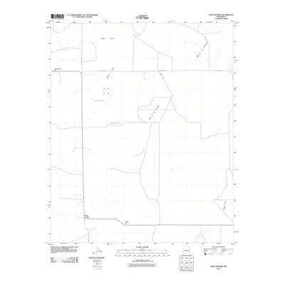
2011 Map of Gran Quivira
USGS Topo · Published 2011About this map
Gran Quivira anchors this high-desert landscape in Torrance County, New Mexico, marking a site of significant archaeological and historical importance. The terrain is characterized by the expansive Mesa de los Jumanos, which dominates the eastern portion of the quadrangle. Sparse water sources define the area's habitation and grazing patterns, notably Wyatt Lake, Espinosa Lake, and Haygood Tank. The road network, including County Rd-B065 and County Rd-B076, connects isolated landforms like Center Point Hill and Beatty Hill. Large, level expanses such as Gooch Flats, Atkinson Flats, and Liberty Valley reflect the open range character of this region during the early 21st century. Infrastructure for ranching and resource management is evident through features like the Transwestern Well, illustrating the ongoing human adaptation to this arid environment.
Find a feature on this map
16 named features on this map. Tap any name to fly to it.
Don’t see what you’re looking for? This feature index may not catch every label — zoom into the map to look around manually.
Map Details
Editions of this 2011 Gran Quivira Map
This is the sole edition of this map. No revisions or reprints were ever made.
Other maps of this area

1954 · Fort Sumner
USGS Topo · 1:250,000

1954 · Socorro
USGS Topo · 1:250,000

1958 · Socorro
USGS Topo · 1:250,000

1958 · Fort Sumner
USGS Topo · 1:250,000

1962 · Socorro
USGS Topo · 1:250,000

1972 · Turkey Ridge
USGS Topo · 1:24,000

1972 · Gran Quivira
USGS Topo · 1:24,000

1972 · Bigbee Draw
USGS Topo · 1:24,000
1972 · Turkey Ridge NE
USGS Topo · 1:24,000
1972 · Mesa Draw
USGS Topo · 1:24,000