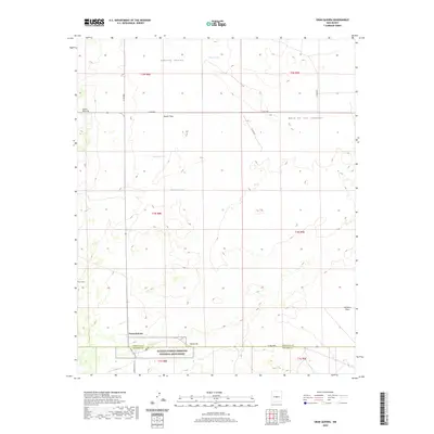
2020 Map of Gran Quivira
USGS Topo · Published 2020About this map
Salinas Pueblo Missions National Monument anchors the southern portion of this high-desert landscape at the boundary of Torrance and Socorro counties. This area around the settlement of Gran Quivira is defined by a series of broad plateaus and basins, most notably the Mesa de los Jumanos and Liberty Valley. The terrain is characterized by numerous seasonal basins and drainage features, including Wyatt Lake, Espinosa Lake, and Haygood Tank, which are critical water-gathering points in this arid environment. The road network consists largely of rural routes such as Co RD 8031 and Co RD 8032, while the presence of WSMR S Route 41 indicates the proximity of military operations within the White Sands Missile Range infrastructure. These topographic details illustrate a sparsely populated region where the environment and archaeology are the primary features of interest.
Find a feature on this map
28 named features on this map. Tap any name to fly to it.
Don’t see what you’re looking for? This feature index may not catch every label — zoom into the map to look around manually.
Map Details
Editions of this 2020 Gran Quivira Map
This is the sole edition of this map. No revisions or reprints were ever made.
Other maps of this area

1954 · Fort Sumner
USGS Topo · 1:250,000

1954 · Socorro
USGS Topo · 1:250,000

1958 · Socorro
USGS Topo · 1:250,000

1958 · Fort Sumner
USGS Topo · 1:250,000

1962 · Socorro
USGS Topo · 1:250,000

1972 · Turkey Ridge
USGS Topo · 1:24,000

1972 · Gran Quivira
USGS Topo · 1:24,000

1972 · Bigbee Draw
USGS Topo · 1:24,000
1972 · Turkey Ridge NE
USGS Topo · 1:24,000
1972 · Mesa Draw
USGS Topo · 1:24,000