
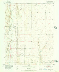
1955 Map of Granada NW
USGS Topo · Published 1956About this map
Big Sandy Creek winds through this Prowers County landscape, defining a terrain shaped by mid-century water management and high-plains agriculture. The 1955 planetable surveys reveal an intricate system of irrigation, featuring the Amity Canal on Levee and the Gomanche Canal, supported by engineering features like a Siphon and Flume. These canals were vital for the region's productivity, as evidenced by the distribution of numerous windmills and wells across the sections.
Find a feature on this map
18 named features on this map. Tap any name to fly to it.
Don’t see what you’re looking for? This feature index may not catch every label — zoom into the map to look around manually.
Map Details
Editions of this 1955 Granada NW Map
2 editions found
Other maps of this area

1890 · Granada
USGS Topo · 1:125,000

1892 · Lamar
USGS Topo · 1:125,000

1892 · Granada
USGS Topo · 1:125,000

1894 · Granada
USGS Topo · 1:125,000

1952 · Carlton
USGS Topo · 1:24,000

1953 · Granada
USGS Topo · 1:24,000

1953 · Lamar East
USGS Topo · 1:24,000

1954 · Lamar
USGS Topo · 1:250,000

1955 · Granada NE
USGS Topo · 1:24,000

1955 · May Valley
USGS Topo · 1:24,000