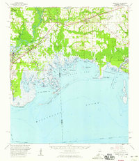
1958 Map of Grand Bay
USGS Topo · Published 1959About this map
The Louisville and Nashville railroad cuts a diagonal path through the coastal lowlands of Alabama and Mississippi, anchoring a string of mid-century communities from Moss Point and Kreole to Grand Bay. The landscape is defined by the complex transition from pine woods to the brackish waters of Grand Bay and Porters Ville Bay. Navigation through the marshes is guided by an intricate network of waterways including Bayou La Batre, Franklin Creek, and the Escatawpa River. Cultural landmarks like the Franklin Creek Ch and several family burying grounds, such as Dees Cem and Kivisto Cem, are preserved here. Along the shoreline, the Grand Batture Islands and Isle aux Herbes buffer the mainland from the open sound, while the Jackson County Airport and the historic Three Notches road mark the evolution of regional transportation.
Find a feature on this map
71 named features on this map. Tap any name to fly to it.
Don’t see what you’re looking for? This feature index may not catch every label — zoom into the map to look around manually.
Map Details
Editions of this 1958 Grand Bay Map
2 editions found
Other maps of this area

1921 · Grand Bay
USGS Topo · 1:62,500

1921 · Petit Bois Island
USGS Topo · 1:62,500

1921 · Dauphin Island
USGS Topo · 1:62,500

1921 · Delchamps
USGS Topo · 1:62,500

1922 · Mobile
USGS Topo · 1:62,500

1940 · Mobile
USGS Topo · 1:62,500

1941 · Cedar Point
USGS Topo · 1:62,500

1941 · Hurley
USGS Topo · 1:62,500

1941 · Vancleave
USGS Topo · 1:62,500

1941 · Horn Island
USGS Topo · 1:62,500