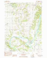
1983 Map of Grand Detour
USGS Topo · Published 1984About this map
The Rock River dominates this landscape, carving a massive horseshoe bend that defines the historic settlement of Grand Detour. This oxbow geography created a natural focal point for early development, now preserved alongside public lands like White Pines Forest State Park and Castle Rock State Park. The map reveals a deeply rooted rural community, marked by small junctions such as Stratford and Kingdom, and family-oriented landmarks like Mt Zion Cemetery and Pine Creek Church. Transportation networks are well-established, with the Burlington Northern and Illinois Central Gulf railroads providing industrial links to the northern edge of Dixon. The presence of several youth and religious retreats, including Rock River Bible Camp and Camp Ralston, suggests the area's long-standing transition from purely agricultural to a recreational destination for the Ogle and Lee County region.
Find a feature on this map
46 named features on this map. Tap any name to fly to it.
Don’t see what you’re looking for? This feature index may not catch every label — zoom into the map to look around manually.
Map Details
Editions of this 1983 Grand Detour Map
This is the sole edition of this map. No revisions or reprints were ever made.
Other maps of this area

1918 · Dixon
USGS Topo · 1:62,500

1922 · Oregon
USGS Topo · 1:62,500

1924 · Oregon
USGS Topo · 1:62,500

1930 · Woodsung
USGS Topo · 1:48,000

1942 · Forreston
USGS Topo · 1:62,500

1945 · Forreston
USGS Topo · 1:62,500

1946 · Sterling
USGS Topo · 1:62,500

1948 · Sterling
USGS Topo · 1:62,500

1950 · Dixon
USGS Topo · 1:62,500

1954 · Rockford
USGS Topo · 1:250,000