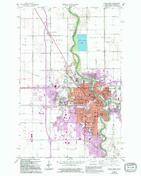
1994 Map of Grand Forks
USGS Topo · Published 1995About this map
The University of North Dakota anchors the central landscape of this Red River Valley survey, which captures the binational character of Grand Forks and East Grand Forks during the mid-1990s. The meandering Red River serves as the focal point and state boundary, joined by the Red Lake River coming from the east. Significant residential and institutional growth is evident through the dense network of named schools, such as Lake Agassiz Sch, Winship Sch, and Schroeder Jr High Sch.
Find a feature on this map
61 named features on this map. Tap any name to fly to it.
Don’t see what you’re looking for? This feature index may not catch every label — zoom into the map to look around manually.
Map Details
Editions of this 1994 Grand Forks Map
This is the sole edition of this map. No revisions or reprints were ever made.
Other maps of this area

1918 · Warren
USGS Topo · 1:62,500

1934 · Grand Forks
USGS Topo · 1:24,000

1934 · Grand Forks
USGS Topo · 1:62,500

1938 · Grand Forks
USGS Topo · 1:62,500

1952 · Grand Forks
USGS Topo · 1:250,000

1952 · Thief River Falls
USGS Topo · 1:250,000

1955 · Warren
USGS Topo · 1:62,500

1956 · Thief River Falls
USGS Topo · 1:250,000

1956 · Grand Forks
USGS Topo · 1:250,000

1957 · Thief River Falls
USGS Topo · 1:250,000