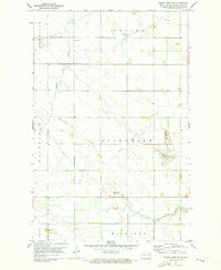
1971 Map of Grand Forks SW
USGS Topo · Published 1973About this map
The agricultural plains of Grand Forks County are defined here by a series of townships including Brenna, Allendale, and Fairfield. This prairie landscape is dissected by several distinct watercourses, most notably the winding path of English Coulee and Wilson Creek. The map documents a rural society organized around section lines and local hubs, such as the Evanger Ch and its adjacent Cem in the northern portion of the survey area. Resource extraction is evident through several industrial sites, including concentrated Gravel Pits and a prominent cross-country Pipeline. These features suggest a period where the traditional farming economy of North Dakota was increasingly supported by modern infrastructure and aggregate mining, providing valuable topographic data for those studying the evolution of land use and family farmsteads in the Red River Valley region.
Find a feature on this map
15 named features on this map. Tap any name to fly to it.
Don’t see what you’re looking for? This feature index may not catch every label — zoom into the map to look around manually.
Map Details
Editions of this 1971 Grand Forks SW Map
This is the sole edition of this map. No revisions or reprints were ever made.
Other maps of this area

1934 · Emerado
USGS Topo · 1:48,000

1934 · Grand Forks
USGS Topo · 1:24,000

1934 · Grand Forks
USGS Topo · 1:62,500

1936 · Emerado
USGS Topo · 1:62,500

1938 · Grand Forks
USGS Topo · 1:62,500

1952 · Grand Forks
USGS Topo · 1:250,000

1956 · Grand Forks
USGS Topo · 1:250,000
1963 · Kelly
USGS Topo · 1:24,000

1963 · Emerado SE
USGS Topo · 1:24,000
1963 · Emerado
USGS Topo · 1:24,000