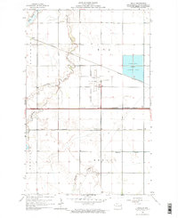
1963 Map of Kelly
USGS Topo · Published 1964About this map
Grand Forks International Airport and its accompanying Beacon anchor this 1963 survey of the plains just west of the Red River Valley. The landscape is defined by its subtle hydrology, where drainage features like Kelly Slough and Salt Water Coulee wind through the prairie townships of Blooming, Rye, and Brenna. Small rural outposts such as Kelly, Powell, and Townhall sit along the corridors of the Northern Pacific and Great Northern railroads, illustrating the transport-driven settlement patterns of the era.
Find a feature on this map
19 named features on this map. Tap any name to fly to it.
Don’t see what you’re looking for? This feature index may not catch every label — zoom into the map to look around manually.
Map Details
Editions of this 1963 Kelly Map
This is the sole edition of this map. No revisions or reprints were ever made.
Other maps of this area

1926 · Ardoch
USGS Topo · 1:62,500

1934 · Emerado
USGS Topo · 1:48,000

1934 · Grand Forks
USGS Topo · 1:24,000

1934 · Grand Forks
USGS Topo · 1:62,500

1936 · Emerado
USGS Topo · 1:62,500

1938 · Grand Forks
USGS Topo · 1:62,500

1952 · Grand Forks
USGS Topo · 1:250,000

1952 · Thief River Falls
USGS Topo · 1:250,000

1956 · Thief River Falls
USGS Topo · 1:250,000

1956 · Grand Forks
USGS Topo · 1:250,000