
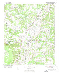
1951 Map of Grand Junction
USGS Topo · Published 1951About this map
The intersection of the Southern and Illinois Central railroads defines the rail-dependent landscape of the Tennessee borderlands in the early 1950s. At the heart of this network lies Grand Junction, a town whose name and identity are bound to this historic junction. The surrounding countryside is dotted with rural institutions that served as the backbone of the community, including several small schools like Woods Sch and New Zion Sch, and local congregations at Prospect Ch and Spring Chapel.
Find a feature on this map
28 named features on this map. Tap any name to fly to it.
Don’t see what you’re looking for? This feature index may not catch every label — zoom into the map to look around manually.
Map Details
Editions of this 1951 Grand Junction Map
2 editions found
Other maps of this area

1949 · Moscow
USGS Topo · 1:62,500

1950 · Ashland
USGS Topo · 1:62,500

1950 · Middleburg
USGS Topo · 1:24,000

1950 · Grand Junction
USGS Topo · 1:24,000

1951 · Middleburg
USGS Topo · 1:24,000

1951 · Hickory Valley
USGS Topo · 1:24,000

1952 · Saulsbury
USGS Topo · 1:24,000

1953 · Holly Springs
USGS Topo · 1:62,500

1956 · Blytheville
USGS Topo · 1:250,000

1956 · Tupelo
USGS Topo · 1:250,000