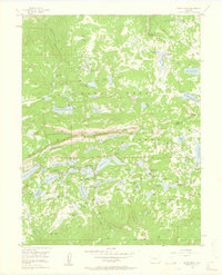
1955 Map of Grand Mesa
USGS Topo · Published 1960About this map
Grand Mesa dominates the landscape in this mid-century survey of the Colorado high country, where the boundary between Mesa Co and Delta Co cuts through a dense concentration of alpine waters. The map reveals an intricate network of reservoirs and irrigation infrastructure essential to the region's development, including Big Creek Reservoir No 1 and the Bullfinch Reservoirs. Evidence of the area's mid-century recreational growth is prominent near Grand Mesa settlement, where the Grand Mesa Christian Association and Columbine Chapel sit alongside numerous public sites like the Skyway Campground and the Ward Lake Ranger Station. This specific topography, defined by features like The Big Slide and the expansive Webb Flats, illustrates the transition from a purely industrial watershed to a hub for seasonal residence and outdoor activity.
Find a feature on this map
97 named features on this map. Tap any name to fly to it.
Don’t see what you’re looking for? This feature index may not catch every label — zoom into the map to look around manually.
Map Details
Editions of this 1955 Grand Mesa Map
5 editions found
Other maps of this area

1955 · Collbran
USGS Topo · 1:24,000

1955 · Grand Mesa
USGS Topo · 1:24,000

1955 · Molina
USGS Topo · 1:24,000

1955 · Skyway
USGS Topo · 1:24,000

1955 · The Meadows
USGS Topo · 1:24,000

1956 · Montrose
USGS Topo · 1:250,000

1956 · Moab
USGS Topo · 1:250,000

1956 · Grand Junction
USGS Topo · 1:250,000

1957 · Leadville
USGS Topo · 1:250,000

1959 · Grand Junction
USGS Topo · 1:250,000