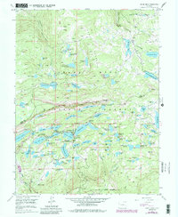
1955 Map of Grand Mesa
USGS Topo · Published 1984About this map
Grand Mesa dominates this 1950s survey, revealing an intricate network of high-altitude water management within the Grand Mesa National Forest. The landscape is defined by dozens of small reservoirs and lakes, such as Atkinson Res and the Bullfinch Reservoirs No 1 No 2, connected by creeks like Michaelsen Creek and Cottonwood Creek. This hydrology supported both the local ecosystem and the seasonal human presence indicated by the Ward Lake Ranger Sta and several organized camps.
Find a feature on this map
95 named features on this map. Tap any name to fly to it.
Don’t see what you’re looking for? This feature index may not catch every label — zoom into the map to look around manually.
Map Details
Editions of this 1955 Grand Mesa Map
5 editions found
Other maps of this area

1955 · Collbran
USGS Topo · 1:24,000

1955 · Grand Mesa
USGS Topo · 1:24,000

1955 · Molina
USGS Topo · 1:24,000

1955 · Skyway
USGS Topo · 1:24,000

1955 · The Meadows
USGS Topo · 1:24,000

1956 · Montrose
USGS Topo · 1:250,000

1956 · Moab
USGS Topo · 1:250,000

1956 · Grand Junction
USGS Topo · 1:250,000

1957 · Leadville
USGS Topo · 1:250,000

1959 · Grand Junction
USGS Topo · 1:250,000