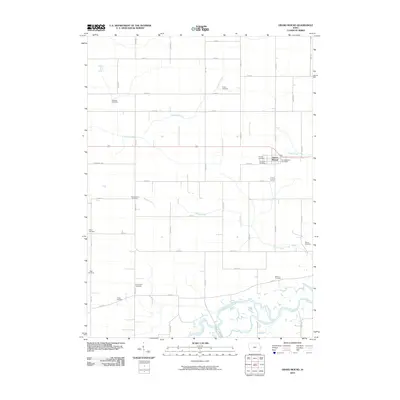
2010 Map of Grand Mound
USGS Topo · Published 2010About this map
Grand Mound serves as the central hub of this eastern Iowa landscape, where the concentrated settlement around the Grand Mound Post Office meets an expansive grid of rural section roads. The terrain is defined by the winding course of the Wapsipinicon River in the south and the smaller drainage systems of Calamus Creek, Crystal Creek, and Barber Creek. This area is particularly notable for its high density of rural burial grounds, which provide a significant genealogical record of the region's farming families. From the centrally located Calvary Cemetery and Evergreen Cemetery near the township center to the more outlying Kvindherred Cemetery, Mowder Cemetery, and Dutton Cemetery, these sites mark the historical distribution of the local community. The landscape reflects a well-established agricultural tradition, with straight-line thoroughfares like Kageman's Rd and 250th St connecting the various family homesteads and landmarks across the prairie.
Find a feature on this map
45 named features on this map. Tap any name to fly to it.
Don’t see what you’re looking for? This feature index may not catch every label — zoom into the map to look around manually.
Map Details
Editions of this 2010 Grand Mound Map
This is the sole edition of this map. No revisions or reprints were ever made.
Other maps of this area

1890 · Durant
USGS Topo · 1:62,500

1891 · DeWitt
USGS Topo · 1:62,500

1891 · Davenport
USGS Topo · 1:62,500

1892 · Wheatland
USGS Topo · 1:62,500

1894 · Wheatland
USGS Topo · 1:62,500

1894 · Durant
USGS Topo · 1:62,500

1894 · Davenport
USGS Topo · 1:62,500

1901 · Rock Island
USGS Topo · 1:125,000

1910 · Rock Island
USGS Topo · 1:125,000
1953 · De Witt
USGS Topo · 1:24,000