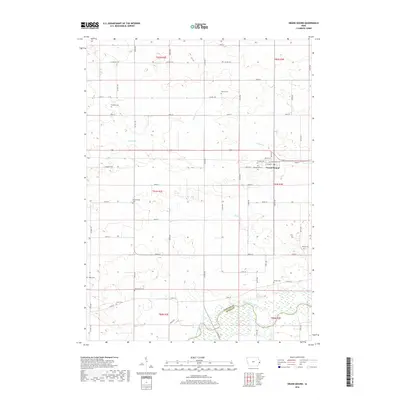
2018 Map of Grand Mound
USGS Topo · Published 2018About this map
The town of Grand Mound sits at the heart of this East-Central Iowa landscape, where a dense grid of section roads meets the rolling terrain between Calamus Cr and the Wapsipinicon River. This 2018 survey documents a region deeply rooted in its rural heritage, evidenced by the unusually high concentration of pioneer and family burial grounds dotting the townships. Genealogists can trace local history through sites such as Kvinnherred Cem and Mowder Cem, while the southern border at the Clinton Co Scott Co line marks the expansive wetlands and floodplains of the river valley. The map details the transition from the concentrated streets of Grand Mound, including Clinton St and Fulton St, to the productive farmland defined by waterways like Barber Cr and Crystal Cr.
Find a feature on this map
42 named features on this map. Tap any name to fly to it.
Don’t see what you’re looking for? This feature index may not catch every label — zoom into the map to look around manually.
Map Details
Editions of this 2018 Grand Mound Map
This is the sole edition of this map. No revisions or reprints were ever made.
Other maps of this area

1890 · Durant
USGS Topo · 1:62,500

1891 · DeWitt
USGS Topo · 1:62,500

1891 · Davenport
USGS Topo · 1:62,500

1892 · Wheatland
USGS Topo · 1:62,500

1894 · Wheatland
USGS Topo · 1:62,500

1894 · Durant
USGS Topo · 1:62,500

1894 · Davenport
USGS Topo · 1:62,500

1901 · Rock Island
USGS Topo · 1:125,000

1910 · Rock Island
USGS Topo · 1:125,000
1953 · De Witt
USGS Topo · 1:24,000