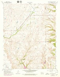
1962 Map of Grand Summit
USGS Topo · Published 1979About this map
The Atchison Topeka and Santa Fe railroad cuts a diagonal path through this Cowley County landscape, centering on the high point of Grand Summit. This early 1960s survey, updated in the late 1970s, captures an era of active resource extraction, evidenced by a large Oil Field and numerous Gas Wells scattered across the southern reaches of Windsor and Otter townships. The rugged topography is defined by the headwaters of several drainage systems, including Cedar Creek and Otter Creek, which are separated by prominent limestone ridges. Local history is anchored by the Gospel Ridge Cem in the southwest corner and the precise elevation data at Spillway Elev 1141. The map also delineates the complex borders where Cowley County meets Elk and Chautauqua counties, illustrating the rural land divisions of Greenfield and Caneyville.
Find a feature on this map
19 named features on this map. Tap any name to fly to it.
Don’t see what you’re looking for? This feature index may not catch every label — zoom into the map to look around manually.
Map Details
Editions of this 1962 Grand Summit Map
2 editions found
Other maps of this area

1885 · Sedan
USGS Topo · 1:125,000

1889 · Burden
USGS Topo · 1:125,000

1889 · Sedan
USGS Topo · 1:125,000

1955 · Wichita
USGS Topo · 1:250,000

1958 · Wichita
USGS Topo · 1:250,000

1962 · Grand Summit
USGS Topo · 1:24,000

1962 · Dexter
USGS Topo · 1:24,000
1962 · Cloverdale
USGS Topo · 1:24,000
1962 · Dexter NE
USGS Topo · 1:24,000
1962 · Grenola
USGS Topo · 1:24,000