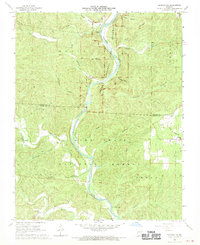
1968 Map of Grandin SW
USGS Topo · Published 1970About this map
The Ozark National Scenic Riverways Current River bisects this landscape, flowing through a heavily forested region on the border of Carter and Ripley counties. This 1960s survey documents the transition toward conservation and recreation, evidenced by the establishment of the Mark Twain National Forest and designated sites like the Hawes Recreation Area. High points such as Battleaxe Ridge and the Panther Lookout Tower provide vantage points over a complex network of hollows, including Gooseneck Hollow and Stillhouse Hollow. Genealogists will find significant local family markers preserved in the Ponder Cemetery, Lewis Cemetery, and Hufstedler Cemetery. Small community centers are noted at Hall and Bedell, while the Good Hope Ch stands near the eastern forest boundary, anchoring the rural settlement pattern of the southern Missouri Ozarks.
Find a feature on this map
39 named features on this map. Tap any name to fly to it.
Don’t see what you’re looking for? This feature index may not catch every label — zoom into the map to look around manually.
Map Details
Editions of this 1968 Grandin SW Map
2 editions found
Other maps of this area

1939 · Doniphan
USGS Topo · 1:62,500

1941 · Gatewood
USGS Topo · 1:62,500

1944 · Van Buren
USGS Topo · 1:62,500

1944 · Grandin
USGS Topo · 1:62,500

1945 · Doniphan
USGS Topo · 1:62,500

1945 · Gatewood
USGS Topo · 1:62,500

1946 · Grandin
USGS Topo · 1:62,500

1946 · Van Buren
USGS Topo · 1:62,500

1957 · Poplar Bluff
USGS Topo · 1:250,000

1959 · Poplar Bluff
USGS Topo · 1:250,000