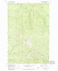
1969 Map of Grandmother Mountain
USGS Topo · Published 1985About this map
St Joe National Forest defines the landscape of Shoshone County in this 1969 survey, revealing a network of drainage basins and high summits that shaped early Idaho logging and mining access. The map tracks the elevation from the headwaters of Marble Creek and the North Fork St Maries River up to the prominent peaks of Grandmother Mtn and Grandfather Mtn. The terrain is marked by a legacy of resource extraction and transit, evidenced by named watercourses like Placer Creek and Gold Center Creek, which hint at the region's mineral history. A complex system of transit, including the Pack Trail and various Jeep Trails, connects remote points such as Davies and Cornwall Point. These paths follow the natural contours of the land, crossing over Freezeout Saddle and along Freezeout Ridge, providing a look at the backcountry infrastructure used by foresters and early explorers.
Find a feature on this map
33 named features on this map. Tap any name to fly to it.
Don’t see what you’re looking for? This feature index may not catch every label — zoom into the map to look around manually.
Map Details
Editions of this 1969 Grandmother Mountain Map
2 editions found

Other maps of this area

1914 · Avery
USGS Topo · 1:125,000

1917 · Avery
USGS Topo · 1:125,000

1923 · Washington Creek
USGS Topo · 1:125,000

1936 · Boehls Butte
USGS Topo · 1:48,000

1943 · Boehls Butte
USGS Topo · 1:62,500

1955 · Pullman
USGS Topo · 1:250,000

1955 · Spokane
USGS Topo · 1:250,000

1956 · Wallace
USGS Topo · 1:250,000

1956 · Hamilton
USGS Topo · 1:250,000

1958 · Spokane
USGS Topo · 1:250,000