
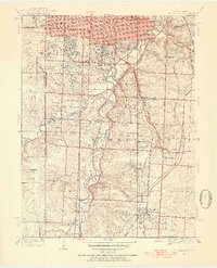
1934 Map of Grandview
USGS Topo · Published 1954About this map
Blue River drainage patterns define the landscape south of Kansas City in the mid-1930s, as the metropolitan area begins to reach into the rural stretches of Jackson County. This survey highlights the complex rail infrastructure of the era, where the San Francisco Pacific and Missouri Pacific lines converge near the settlement of Dodson. Local life is anchored by a network of community institutions, from the Ruskin High Sch in the east to the historic crossroads of New Santa Fe on the Kansas border. Numerous golf clubs and parks, including Swope Park and the South Ridge Country Club, suggest a landscape in transition from agricultural use to suburban recreation. Further south, the map details established communities such as Hickman Mills and Martin City, along with notable landmarks like Camp Billy Ca and several large cemeteries including Forest Hill Cem and Mt Moriah Cemetery.
Find a feature on this map
53 named features on this map. Tap any name to fly to it.
Don’t see what you’re looking for? This feature index may not catch every label — zoom into the map to look around manually.
Map Details
Editions of this 1934 Grandview Map
3 editions found
Other maps of this area

1887 · Harrisonville
USGS Topo · 1:125,000

1887 · Olathe
USGS Topo · 1:125,000

1890 · Kansas City
USGS Topo · 1:125,000

1892 · Harrisonville
USGS Topo · 1:125,000

1893 · Olathe
USGS Topo · 1:125,000

1894 · Kansas City
USGS Topo · 1:125,000

1894 · Harrisonville
USGS Topo · 1:125,000

1894 · Independence
USGS Topo · 1:125,000

1934 · Independence
USGS Topo · 1:24,000

1934 · Grandview
USGS Topo · 1:24,000