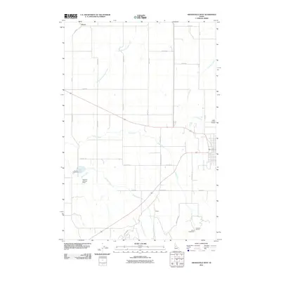
2010 Map of Grangeville West
USGS Topo · Published 2010About this map
Denver sits at the northern edge of this Camas Prairie landscape, where the plateau is deeply incised by the drainage systems of the Clearwater River basin. The area's agricultural character is defined by a rigorous grid of section-line roads, including Prairie Rd and Tolo Lake Rd, which connect the scattered rural settlements and industrial sites. Water management and local resources are central to the region, evidenced by the Grangeville Hatchery and Johns Creek Dam located near the eastern outskirts of the quadrangle. Significant natural landmarks like Tolo Lake and the Harrison Johnson Draw break the geometric pattern of the wheat fields. The presence of the Idaho County Airport and the modern alignment of Old Hwy 95 alongside newer routes illustrates the evolution of transport in this vital Idaho panhandle farming hub.
Find a feature on this map
31 named features on this map. Tap any name to fly to it.
Don’t see what you’re looking for? This feature index may not catch every label — zoom into the map to look around manually.
Map Details
Editions of this 2010 Grangeville West Map
This is the sole edition of this map. No revisions or reprints were ever made.
Other maps of this area

1924 · Kamiah
USGS Topo · 1:125,000

1955 · Pullman
USGS Topo · 1:250,000

1955 · Grangeville
USGS Topo · 1:250,000

1958 · Pullman
USGS Topo · 1:250,000

1959 · Grangeville
USGS Topo · 1:250,000

1963 · Goodwin Meadows
USGS Topo · 1:24,000

1963 · Grangeville West
USGS Topo · 1:24,000

1963 · White Bird Hill
USGS Topo · 1:24,000
1963 · Grangeville East
USGS Topo · 1:24,000

1963 · White Bird
USGS Topo · 1:24,000