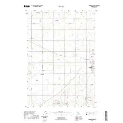
2020 Map of Grangeville West
USGS Topo · Published 2020About this map
Grangeville and the surrounding agricultural plateau of Idaho County are defined by a network of drainage systems and rural transit routes. The landscape transitions from the residential street grid of the county seat to the open prairies near Denver. Significant water features like Tolo Lake and the S Fork Cottonwood Cr cut through the terrain, creating distinct landforms such as Rocky Canyon and Meyer Gulch. The area serves as a local aviation hub, with both the Idaho County Airport and the smaller Wind Ridge Airport positioned to support the region's connectivity. Navigating the township lines of T30N R2E and T31N R3E reveals a persistent grid of farm-to-market roads, including Old Hwy 7 and Denver Rd, which trace the history of land division and settlement in this part of northern Idaho.
Find a feature on this map
76 named features on this map. Tap any name to fly to it.
Don’t see what you’re looking for? This feature index may not catch every label — zoom into the map to look around manually.
Map Details
Editions of this 2020 Grangeville West Map
This is the sole edition of this map. No revisions or reprints were ever made.
Other maps of this area

1924 · Kamiah
USGS Topo · 1:125,000

1955 · Pullman
USGS Topo · 1:250,000

1955 · Grangeville
USGS Topo · 1:250,000

1958 · Pullman
USGS Topo · 1:250,000

1959 · Grangeville
USGS Topo · 1:250,000

1963 · Goodwin Meadows
USGS Topo · 1:24,000

1963 · Grangeville West
USGS Topo · 1:24,000

1963 · White Bird Hill
USGS Topo · 1:24,000
1963 · Grangeville East
USGS Topo · 1:24,000

1963 · White Bird
USGS Topo · 1:24,000