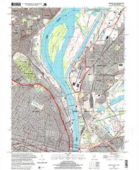
1998 Map of Granite City
USGS Topo · Published 1999About this map
The Mississippi River dominates this industrial and urban landscape, serving as the boundary between Missouri and Illinois. On the western bank, the northern neighborhoods of St Louis and Bellefontaine Neighbors appear alongside massive green spaces like Calvary Cemetery and Bellefontaine Cemetery. The river's engineering is on full display with the Chain of Rocks Canal and Lock No 27 bypassing the main channel's natural obstructions near Cabaret Island.
Find a feature on this map
62 named features on this map. Tap any name to fly to it.
Don’t see what you’re looking for? This feature index may not catch every label — zoom into the map to look around manually.
Map Details
Editions of this 1998 Granite City Map
This is the sole edition of this map. No revisions or reprints were ever made.
Other maps of this area

1888 · St. Louis
USGS Topo · 1:62,500

1927 · Alton
USGS Topo · 1:62,500

1927 · St. Charles
USGS Topo · 1:62,500

1931 · French Village
USGS Topo · 1:24,000

1933 · Granite City
USGS Topo · 1:24,000

1933 · Jefferson Barracks
USGS Topo · 1:24,000

1933 · Cahokia
USGS Topo · 1:24,000

1933 · Clayton
USGS Topo · 1:24,000

1933 · Saint Charles
USGS Topo · 1:62,500

1934 · Cahokia
USGS Topo · 1:24,000