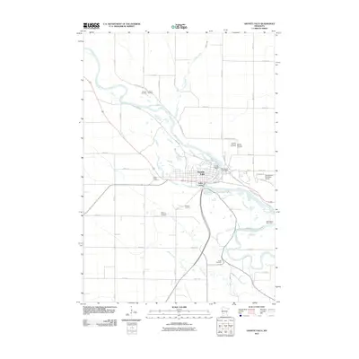
2010 Map of Granite Falls
USGS Topo · Published 2010About this map
Minnesota River hydraulics and civic infrastructure anchor this 2010 study of the Granite Falls area. The river winds through the landscape, marked by industrial and natural landmarks such as the Minnesota River Dam and the cascades of Minnesota Falls. This reach of the river valley is characterized by a high density of rural and municipal burial grounds, providing significant data for genealogical research. Documented sites include Granite Falls City Cemetery, Union Cemetery, Saint Pauls Cemetery, Saint Andrews Cemetery, and Hillcrest Cemetery, each reflecting the community's long-established settlement patterns.
Find a feature on this map
49 named features on this map. Tap any name to fly to it.
Don’t see what you’re looking for? This feature index may not catch every label — zoom into the map to look around manually.
Map Details
Editions of this 2010 Granite Falls Map
This is the sole edition of this map. No revisions or reprints were ever made.
Other maps of this area

1953 · New Ulm
USGS Topo · 1:250,000

1957 · New Ulm
USGS Topo · 1:250,000

1958 · New Ulm
USGS Topo · 1:250,000

1962 · Wood Lake NW
USGS Topo · 1:24,000

1962 · Wood Lake
USGS Topo · 1:24,000

1965 · Montevideo
USGS Topo · 1:24,000

1965 · Lone Tree Lake
USGS Topo · 1:24,000

1965 · Asbury
USGS Topo · 1:24,000

1965 · Hazel Run
USGS Topo · 1:24,000
1965 · Maynard
USGS Topo · 1:24,000