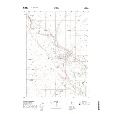
2019 Map of Granite Falls
USGS Topo · Published 2019About this map
The Minnesota River carves a winding path through this region, forming the natural border between Chippewa Co and Yellow Medicine Co. The city of Granite Falls serves as the central hub, situated along the river's bend where modern infrastructure like the Minnesota West Community and Technical College and the Granite Falls Municipal Airport are established. This 2019 survey documents a landscape defined by its agricultural heritage and water management, evidenced by features such as County Ditch Number Seventy and County Ditch Number Six a. For genealogists and local historians, the map is particularly useful for locating numerous burial sites scattered across the township lines, including Dueland Cem, Granite Falls City Cem, Saint Pauls Cem, Saint Andrews Cem, Hillcrest Cem, and Union Cem, many of which sit near the banks of Palmer Cr and Hazel Cr.
Find a feature on this map
25 named features on this map. Tap any name to fly to it.
Don’t see what you’re looking for? This feature index may not catch every label — zoom into the map to look around manually.
Map Details
Editions of this 2019 Granite Falls Map
This is the sole edition of this map. No revisions or reprints were ever made.
Other maps of this area

1953 · New Ulm
USGS Topo · 1:250,000

1957 · New Ulm
USGS Topo · 1:250,000

1958 · New Ulm
USGS Topo · 1:250,000

1962 · Wood Lake NW
USGS Topo · 1:24,000

1962 · Wood Lake
USGS Topo · 1:24,000

1965 · Montevideo
USGS Topo · 1:24,000

1965 · Lone Tree Lake
USGS Topo · 1:24,000

1965 · Asbury
USGS Topo · 1:24,000

1965 · Hazel Run
USGS Topo · 1:24,000
1965 · Maynard
USGS Topo · 1:24,000