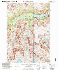
1996 Map of Granite Peak
USGS Topo · Published 1999About this map
Granite Peak anchors this high-elevation survey of the Montana wilderness, marking a convergence of major natural boundaries. The map documents a landscape defined by glacial features and remote water bodies, including the Granite Glacier and the formidable Froze to Death Mountain. It captures the intersection of the Custer National Forest and Gallatin National Forest, entirely contained within the protected Absaroka-Beartooth Wilderness. Human influence is sparse and concentrated at the Montana Power Dam on the eastern shore of Mystic Lake. This reservoir, fed by West Rosebud Creek, represents one of the few structural landmarks in a terrain otherwise characterized by a dense network of alpine basins like Avalanche Lake and Island Lake, and the headwaters of the Stillwater River.
Find a feature on this map
45 named features on this map. Tap any name to fly to it.
Don’t see what you’re looking for? This feature index may not catch every label — zoom into the map to look around manually.
Map Details
Editions of this 1996 Granite Peak Map
2 editions found
Other maps of this area

1898 · Granite Mountain District
USGS Topo · 1:125,000

1932 · Nye No 1
USGS Topo · 1:48,000

1932 · Nye No 2
USGS Topo · 1:48,000

1939 · Mt Wood
USGS Topo · 1:62,500

1941 · Mt. Wood
USGS Topo · 1:62,500

1954 · Billings
USGS Topo · 1:250,000
1956 · Emerald Lake
USGS Topo · 1:24,000

1956 · Alpine
USGS Topo · 1:62,500

1956 · Cooke City
USGS Topo · 1:62,500

1957 · Billings
USGS Topo · 1:250,000