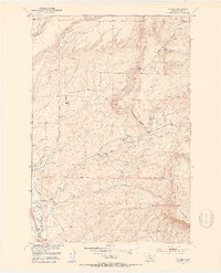
1951 Map of Grannis
USGS Topo · Published 1953About this map
Shields River valley life in the early 1950s is defined by a network of family-operated ranches and vital irrigation systems. The landscape is dotted with established holdings such as the Eyman Ranch, Bonhomme Ranch, and Bohleen Ranch, reflecting the agricultural roots of Park County. Water management is central to the area's viability, evidenced by the Lower Shields Valley Ditch and Palmer Ditch which cut through the terrain to support local livestock operations.
Find a feature on this map
25 named features on this map. Tap any name to fly to it.
Don’t see what you’re looking for? This feature index may not catch every label — zoom into the map to look around manually.
Map Details
Editions of this 1951 Grannis Map
4 editions found
Other maps of this area

1891 · Livingston
USGS Topo · 1:250,000

1893 · Livingston
USGS Topo · 1:250,000

1947 · Bozeman
USGS Topo · 1:250,000

1948 · Bozeman
USGS Topo · 1:250,000

1951 · Ibex Mountain
USGS Topo · 1:24,000

1951 · Clyde Park
USGS Topo · 1:24,000

1951 · Chadborn
USGS Topo · 1:24,000

1951 · Grannis
USGS Topo · 1:24,000

1951 · Hunters Hot Springs
USGS Topo · 1:24,000

1951 · Elton
USGS Topo · 1:24,000