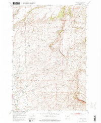
1951 Map of Grannis
USGS Topo · Published 1976About this map
Shields River valley life in the early 1950s is defined by a network of family-held homesteads and rural irrigation projects. The map documents several named ranching properties, including the Eyman Ranch, Hetzel Ranch, and Bohleen Ranch, illustrating the dispersed settlement pattern of this Montana landscape. Education for these rural families centered on the Falls Creek School and Grannis School, which served the small community of Grannis near the southern boundary.
Find a feature on this map
21 named features on this map. Tap any name to fly to it.
Don’t see what you’re looking for? This feature index may not catch every label — zoom into the map to look around manually.
Map Details
Editions of this 1951 Grannis Map
4 editions found
Other maps of this area

1891 · Livingston
USGS Topo · 1:250,000

1893 · Livingston
USGS Topo · 1:250,000

1947 · Bozeman
USGS Topo · 1:250,000

1948 · Bozeman
USGS Topo · 1:250,000

1951 · Ibex Mountain
USGS Topo · 1:24,000

1951 · Clyde Park
USGS Topo · 1:24,000

1951 · Chadborn
USGS Topo · 1:24,000

1951 · Grannis
USGS Topo · 1:24,000

1951 · Hunters Hot Springs
USGS Topo · 1:24,000

1951 · Elton
USGS Topo · 1:24,000