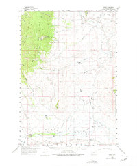
1959 Map of Grant
USGS Topo · Published 1975About this map
Horse Prairie dominates the southern landscape of this Beaverhead County region, where the settlement of Grant serves as a focal point for a remote ranching and mining district. The map records a series of established family holdings, including the Christensen Ranch, Hughes Ranch, and Pierce Ranch, which are situated along the drainages of Painter Creek and Horse Prairie Creek. This late-1950s survey captures the era before significant modernization, showing a landscape defined by traditional land use and early resource extraction.
Find a feature on this map
48 named features on this map. Tap any name to fly to it.
Don’t see what you’re looking for? This feature index may not catch every label — zoom into the map to look around manually.
Map Details
Editions of this 1959 Grant Map
3 editions found

Other maps of this area

1893 · Dillon
USGS Topo · 1:250,000

1952 · Bannack
USGS Topo · 1:24,000

1952 · Eli Spring
USGS Topo · 1:24,000

1952 · Ermont
USGS Topo · 1:24,000

1955 · Dubois
USGS Topo · 1:250,000

1955 · Dillon
USGS Topo · 1:250,000

1957 · Dillon
USGS Topo · 1:250,000

1958 · Dubois
USGS Topo · 1:250,000

1958 · Dillon
USGS Topo · 1:250,000

1959 · Polaris
USGS Topo · 1:62,500