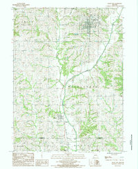
1984 Map of Grant City
USGS Topo · Published 1985About this map
Grant City serves as the focal point of this mid-1980s topography, situated in a landscape defined by the drainage basins of several prominent local waterways. The Middle Fork Grand River cuts across the central terrain, joined by tributaries including Bear Creek, Marlowe Creek, and Peddler Creek. These natural watercourses dictated early settlement patterns, while the industrial and transport history of the region is evidenced by an Old Railroad Grade that speaks to former rail connectivity before the mid-century decline of many rural lines. The northern section is dominated by the Fletchall township, while the small community of Worth lies to the south near the boundary with Gentry Co. Higher elevations are marked by landmarks like Mt Waller, providing a clear view of the agricultural townships and the local Golf Course.
Find a feature on this map
21 named features on this map. Tap any name to fly to it.
Don’t see what you’re looking for? This feature index may not catch every label — zoom into the map to look around manually.
Map Details
Editions of this 1984 Grant City Map
This is the sole edition of this map. No revisions or reprints were ever made.
Other maps of this area

1940 · Blockton
USGS Topo · 1:62,500

1940 · Bedford
USGS Topo · 1:62,500

1940 · Parnell
USGS Topo · 1:62,500

1942 · Grant City
USGS Topo · 1:62,500

1943 · Bedford
USGS Topo · 1:62,500

1943 · Parnell
USGS Topo · 1:62,500

1943 · Grant City
USGS Topo · 1:62,500

1943 · Blockton
USGS Topo · 1:62,500

1955 · Nebraska City
USGS Topo · 1:250,000

1957 · Nebraska City
USGS Topo · 1:250,000