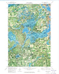
1972 Map of Grant Lake
USGS Topo · Published 1974About this map
The Mississippi Headwaters State Forest dominates this northern landscape, following the winding course of the upper Mississippi River as it flows south through the marshy lowlands of Jones and Grant Valley. This early 1970s orthophotomap provides a rare visual synthesis of the region's complex hydrology, where Grant Creek drains into the larger river system through a network of smaller basins like Rice Lake and Bootleg Lake. In the northern section, Roglien Memorial Park sits on the shores of Grant Lake, which is overlooked by a prominent Lookout Tower. The map documents the interface of managed timberlands and recreation at the transition from the headwaters forest to the Paul Bunyan State Forest further south. Local industry is visible in the scattered Gravel Pit locations, while the presence of the Beltrami Co Hubbard Co line indicates the administrative division of this water-rich territory.
Find a feature on this map
19 named features on this map. Tap any name to fly to it.
Don’t see what you’re looking for? This feature index may not catch every label — zoom into the map to look around manually.
Map Details
Editions of this 1972 Grant Lake Map
This is the sole edition of this map. No revisions or reprints were ever made.
Other maps of this area

1919 · Solway
USGS Topo · 1:62,500

1920 · Buena Vista
USGS Topo · 1:62,500

1943 · Solway
USGS Topo · 1:62,500

1954 · Bemidji
USGS Topo · 1:250,000

1957 · Bemidji
USGS Topo · 1:250,000

1958 · Bemidji
USGS Topo · 1:250,000

1968 · Frontenac Lake
USGS Topo · 1:24,000

1968 · Bemidji West
USGS Topo · 1:24,000

1972 · Alida
USGS Topo · 1:24,000

1972 · Peterson Lake
USGS Topo · 1:24,000