
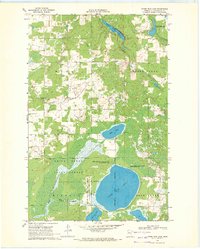
1972 Map of Alida
USGS Topo · Published 1974About this map
The Mississippi Headwaters State Forest dominates the southeastern portion of this landscape, where the newborn Mississippi River begins its long journey south. This orthophotomap, based on 1969 aerial photography and 1972 topography, provides a rare visual record of the glacial lake country at the intersection of Clearwater, Beltrami, and Hubbard counties. The small settlement of Alida serves as a local anchor, surrounded by a complex network of wetlands and drainage systems including Bear Creek and the Little Mississippi River.
Find a feature on this map
15 named features on this map. Tap any name to fly to it.
Don’t see what you’re looking for? This feature index may not catch every label — zoom into the map to look around manually.
Map Details
Editions of this 1972 Alida Map
This is the sole edition of this map. No revisions or reprints were ever made.
Other maps of this area

1919 · Solway
USGS Topo · 1:62,500

1943 · Solway
USGS Topo · 1:62,500

1943 · Bagley
USGS Topo · 1:62,500

1954 · Bemidji
USGS Topo · 1:250,000

1957 · Bemidji
USGS Topo · 1:250,000

1958 · Bemidji
USGS Topo · 1:250,000

1969 · Shevlin
USGS Topo · 1:24,000

1969 · Heart Lake
USGS Topo · 1:24,000
1969 · Upper Rice Lake
USGS Topo · 1:24,000

1972 · La Salle Lake
USGS Topo · 1:24,000