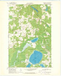
1969 Map of Upper Rice Lake
USGS Topo · Published 1972About this map
Upper Rice Lake anchors this landscape in the late 1960s, situated at the intersection of protected wilderness and local industry. The map captures the significant environmental and jurisdictional boundaries of Clearwater County, including the White Earth Indian Reservation and the White Earth State Forest. This territory is defined by its complex hydrology, where the Wild Rice River flows south from the main lake, and smaller bodies of water like Mud Lake and Minerva Lake dot the wetlands. Human presence is concentrated near the township lines of Nora and Moose Creek, evidenced by community landmarks such as Bethel Ch and the Nora Cem. The prevalence of several wildlife management areas reflects a managed wilderness character, while scattered Gravel Pit sites and a prominent Pipeline indicate the extraction and transport activities shaping the rural economy during this era.
Find a feature on this map
20 named features on this map. Tap any name to fly to it.
Don’t see what you’re looking for? This feature index may not catch every label — zoom into the map to look around manually.
Map Details
Editions of this 1969 Upper Rice Lake Map
This is the sole edition of this map. No revisions or reprints were ever made.
Other maps of this area

1919 · Solway
USGS Topo · 1:62,500

1943 · Solway
USGS Topo · 1:62,500

1943 · Bagley
USGS Topo · 1:62,500

1954 · Bemidji
USGS Topo · 1:250,000

1957 · Bemidji
USGS Topo · 1:250,000

1958 · Bemidji
USGS Topo · 1:250,000
1969 · Bagley
USGS Topo · 1:24,000

1969 · Shevlin
USGS Topo · 1:24,000
1969 · Zerkel
USGS Topo · 1:24,000

1969 · Heart Lake
USGS Topo · 1:24,000