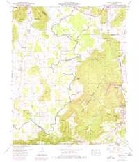
1947 Map of Grant
USGS Topo · Published 1975About this map
Paint Rock River defines the valley floor as it meanders through the borders of Madison and Marshall Counties, its course marked by river miles and historic crossings like Hellum Ford and Fishtrap Ford. To the east, Gunters Mountain rises sharply, where the community of Grant sits atop the plateau near the D A R Sch and its athletic field. The landscape is a complex arrangement of sharp ridges and deep hollows, including Woodall Hollow and Keel Hollow, which dictate the placement of early settlements and roads.
Find a feature on this map
84 named features on this map. Tap any name to fly to it.
Don’t see what you’re looking for? This feature index may not catch every label — zoom into the map to look around manually.
Map Details
Editions of this 1947 Grant Map
4 editions found
Other maps of this area

1885 · Gadsden
USGS Topo · 1:125,000

1888 · Gadsden
USGS Topo · 1:125,000

1888 · Scottsboro
USGS Topo · 1:125,000

1892 · Scottsboro
USGS Topo · 1:125,000

1892 · Gadsden
USGS Topo · 1:125,000

1895 · Gadsden
USGS Topo · 1:125,000

1903 · Gadsden
USGS Topo · 1:125,000

1936 · Columbus City
USGS Topo · 1:24,000

1936 · New Hope
USGS Topo · 1:24,000

1936 · Guntersville Dam
USGS Topo · 1:24,000