
1960 Map of Grass Creek
USGS Topo · Published 1980About this map
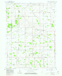
Grass Creek serves as a central point in this rural landscape, situated at the intersection of a complex drainage network that includes Grassy Creek and Mill Creek. The map reveals a deeply established agricultural community where civic life revolved around small country churches and cemeteries, such as Mull Ch and the Old Indian Creek Cem. The terrain is defined by an extensive system of man-made waterways like Gillespie Ditch and Weasner Ditch, which converted the natural wetlands into productive farmland. Settlement patterns are sparse, with named locations like Newton, Montgomery, and Boon punctuating the grid of section lines and early roads like Pennsylvania Road. This 1960 era survey also highlights the local reliance on the earth, with several Gravel Pits noted near the winding path of Indian Creek.
Find a feature on this map
45 named features on this map. Tap any name to fly to it.
Don’t see what you’re looking for? This feature index may not catch every label — zoom into the map to look around manually.
Map Details
Editions of this 1960 Grass Creek Map
3 editions found
Other maps of this area

1953 · Chicago
USGS Topo · 1:250,000

1953 · Danville
USGS Topo · 1:250,000

1955 · Danville
USGS Topo · 1:250,000

1955 · Logansport
USGS Topo · 1:24,000

1956 · Danville
USGS Topo · 1:250,000

1957 · Chicago
USGS Topo · 1:250,000

1960 · Lucerne
USGS Topo · 1:24,000

1960 · Fulton
USGS Topo · 1:24,000

1960 · Grass Creek
USGS Topo · 1:24,000

1962 · Pershing
USGS Topo · 1:24,000