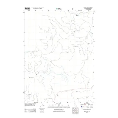
2012 Map of Grass Lake
USGS Topo · Published 2012About this map
Grass Lake anchors the southern portion of this high-elevation terrain in Siskiyou County, where the landscape is defined by the drainage networks of Dairy Cr and Bear Wallow Cr. The area reflects a history of remote land management and seasonal grazing, evidenced by features like Bull Meadow and the isolated Davis Cabin to the east. Navigational access in this period relied on primitive routes such as Miller Mt Rd and the Ball Mtn Little Shasta Rd, which skirt the lower slopes of prominent summits. To the west, Miller Mountain and Herd Peak rise above the drainage basins, while the presence of First Spring and Bearwallow Spring highlights the critical water sources that once supported forestry and ranching operations in this part of Northern California.
Find a feature on this map
23 named features on this map. Tap any name to fly to it.
Don’t see what you’re looking for? This feature index may not catch every label — zoom into the map to look around manually.
Map Details
Editions of this 2012 Grass Lake Map
This is the sole edition of this map. No revisions or reprints were ever made.
Other maps of this area

1886 · Shasta
USGS Topo · 1:250,000

1894 · Shasta
USGS Topo · 1:250,000

1922 · Shasta Valley Sheet No 10 E
USGS Topo · 1:24,000

1934 · Macdoel
USGS Topo · 1:96,000

1941 · Macdoel
USGS Topo · 1:125,000

1948 · Weed
USGS Topo · 1:250,000

1950 · Weed
USGS Topo · 1:250,000

1954 · The Whaleback
USGS Topo · 1:62,500

1954 · Macdoel
USGS Topo · 1:62,500
1954 · Copco
USGS Topo · 1:62,500